

Where is Dubai? Dubai is a city and emirate in the United Arab Emirates (UAE), located on the southeastern coast of the Arabian Gulf on the Arabian Peninsula. It is one of the seven emirates that make up the UAE and is positioned between major markets across the Middle East, Asia, Europe and Africa.
Dubai is widely known for its skyscrapers and modern infrastructure, but its geography is much broader. The Emirate of Dubai includes a long Gulf coastline, sandy desert, Dubai Creek, densely developed urban areas and the mountainous Hatta region.
Where Is Dubai Located?
Where is Dubai located? Dubai is on the southeastern coast of the Arabian Gulf, in the eastern part of the Arabian Peninsula.
Dubai is part of the UAE and sits between Abu Dhabi and Sharjah. Abu Dhabi lies to the south, while Sharjah is northeast of Dubai. The Emirate of Dubai also extends southeast toward the Hatta region near the border with Oman.
Its coastal position has always been important to Dubai. The Gulf provided access to maritime trade, while its position within the UAE connected it with the wider Arabian Peninsula.
Dubai Geography: Coastline, Desert, Islands, Creek & Hatta
Dubai Districts and Areas: Sectors, Urban Centres & City Structure
Dubai Creek: How the Waterway Shaped the City’s Growth
Dubai Location on the Map
Dubai location is on the western side of the UAE, facing the Arabian Gulf.
When looking at a map of the UAE, Dubai sits along the country’s northern Gulf coastline, between Abu Dhabi and Sharjah. The main city is concentrated around the coast, while the wider emirate extends inland across desert areas.
The location places Dubai within easy reach of several major international regions. Asia, Europe and Africa can all be reached through established air and maritime connections from the city.
Dubai Geography: Coast, Desert and Urban Areas
Dubai geography consists of several different physical environments.
The coastal part of Dubai contains beaches, shallow Gulf waters and heavily developed urban areas. Moving inland, the landscape changes into sandy desert, with large areas remaining outside the main built-up city.
Dubai also has a distinctive inland mountainous region around Hatta. This makes the geography of the emirate more varied than the modern skyline might suggest.
The main geographical features include:
- Arabian Gulf coastline
- Sandy desert
- Dubai Creek
- Developed urban areas
- Inland desert regions
- Hatta and the surrounding mountains
Together, these features form the physical landscape of the Emirate of Dubai.
How Big Is Dubai?
How big is Dubai? The Emirate of Dubai covers approximately 4,114 square kilometres.
This figure refers to the entire emirate rather than only the densely developed central city.
A significant portion of Dubai’s territory consists of desert and less densely developed land. The famous areas filled with skyscrapers, roads, commercial buildings and residential developments represent only part of the emirate.
Dubai is the second-largest emirate in the UAE by area, after Abu Dhabi.
What Is the Population of Dubai?
What is the population of Dubai? Dubai has a population of more than four million people, according to recent official Dubai figures.
The population has grown substantially as Dubai has developed into an international centre for business, employment, trade and services.
Dubai’s population is also highly diverse. People from many countries live and work in the emirate, creating one of the most internationally diverse urban populations in the region.
Most residents live in the developed urban areas, while the desert and more remote parts of the emirate have much lower population density.
Is Dubai a City or an Emirate?
Dubai is both a city and an emirate, and this distinction is important.
The City of Dubai is the major urban centre where most of the population, businesses and infrastructure are concentrated.
The Emirate of Dubai is the larger administrative territory. It includes the city as well as desert areas, coastal territory and Hatta.
This is why information about Dubai’s area or population can sometimes appear different depending on whether the source is referring to the city, urban area or entire emirate.
Dubai Coastline and the Arabian Gulf
Dubai has a coastline of roughly 72 kilometres along the Arabian Gulf.
The coast has played an important role in the development of the city. Dubai’s maritime position supported fishing, pearling and trading activities before the emirate developed into a modern international business centre.
Today, the coastline contains a mixture of natural shorelines and heavily developed waterfront areas.
Large-scale land reclamation has also changed sections of Dubai’s coastline and created new waterfront landscapes.
Dubai Creek and Its Geographic Importance
Dubai Creek is one of the most important geographical features in the city.
The natural waterway extends inland from the Arabian Gulf and historically provided a sheltered location for maritime activity.
Dubai Creek helped shape the early physical structure of the city. Deira developed on the northern side of the Creek, while Bur Dubai developed on the southern side.
Long before Dubai became famous for skyscrapers, the Creek was closely connected with fishing, pearling, trading and the movement of goods.
Its geographical importance can still be seen in the structure of older parts of Dubai.
The Desert in Dubai
The Dubai desert covers large areas beyond the main urban zone.
The sandy landscape is very different from the dense development around central Dubai. As you move away from the city, high-rise buildings and major roads gradually give way to open desert and sand dunes.
This desert environment forms a major part of the Emirate of Dubai and is one of the clearest examples of the contrast between Dubai’s natural landscape and its modern built environment.
Hatta: Dubai’s Mountainous Region
Hatta is one of the most unusual geographical parts of the Emirate of Dubai.
While the main city is a coastal and largely flat urban environment, Hatta is located in a mountainous landscape associated with the Hajar Mountains.
The area contains rocky terrain, valleys and wadis, creating a landscape that looks completely different from central Dubai.
Hatta therefore shows why the geography of the Emirate of Dubai cannot be understood by looking only at the modern coastal city.
Why Is Dubai’s Location Important?
Dubai’s geographical position has been one of its major advantages.
The emirate sits beside the Arabian Gulf and is positioned close to major markets connecting the Middle East with Asia, Europe and Africa.
This location has supported the development of:
- International trade
- Aviation
- Maritime transport
- Logistics
- Business services
- Tourism
- Global commerce
Dubai’s location alone did not create its modern economy, but it provided an important geographical foundation for the city’s growth.
Dubai’s Geography at a Glance
Dubai can be understood through five major geographical elements:
Arabian Gulf: The coastline forms the western edge of the emirate and has influenced Dubai’s maritime development.
Dubai Creek: A natural waterway that played an important role in the early growth and structure of the city.
Desert: Large areas of the emirate consist of sandy desert beyond the main urban zone.
Urban Dubai: The highly developed coastal city contains major infrastructure, residential areas, commercial centres and modern buildings.
Hatta: The mountainous inland part of the emirate provides a completely different physical landscape.
Dubai Is More Than Its Skyline
Dubai is often represented by skyscrapers, modern highways and spectacular architecture. But those features are only one part of the emirate.
The wider geographical picture includes the Arabian Gulf, desert, Creek, urban development and mountains.
Understanding where Dubai is, its geographical position, its size and its population provides a useful foundation for understanding the city before exploring its districts, landmarks and other physical features.
Conclusion
Where is Dubai? Dubai is located on the southeastern coast of the Arabian Gulf in the United Arab Emirates, on the Arabian Peninsula.
The Emirate of Dubai covers about 4,114 square kilometres and has a population of more than four million. Its geography includes a Gulf coastline, sandy desert, Dubai Creek, a highly developed urban centre and the mountainous Hatta region.
Dubai’s location has helped connect it with major markets around the world, while its varied physical geography has shaped the way the emirate has developed.
Beyond the famous skyline, Dubai is a much larger geographical place — a combination of coast, desert, waterway, city and mountains.


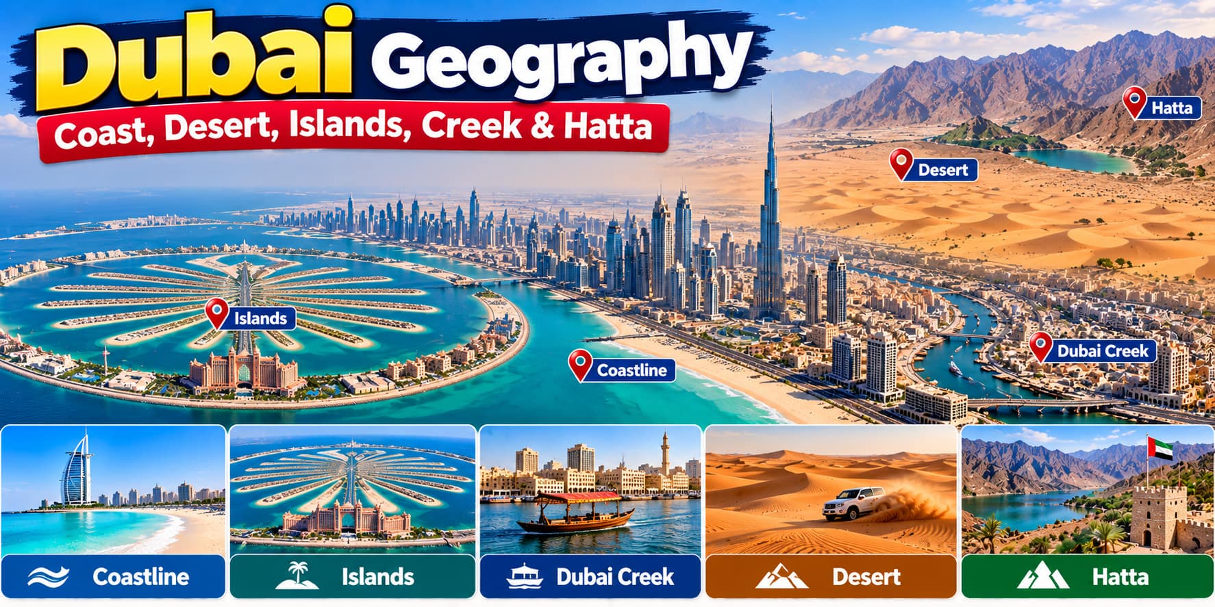









Dubai Geography: Coast, Desert, Islands, Creek & Hatta
[…] Where Is Dubai? Geography, Location, Size & Population […]