

Dubai geography is defined by a striking combination of Arabian Gulf coastline, sandy desert, natural waterways, artificial islands and the mountainous landscape around Hatta. Although Dubai is best known for its modern skyline, its physical landscape extends far beyond the central city.
From the flat coastal plain to the desert interior and the Hajar Mountains near Hatta, the geography of Dubai changes significantly across the emirate. Human engineering has also reshaped parts of the coastline, creating reclaimed land and artificial islands that have become distinctive features of the modern Dubai landscape.
Dubai Coastline and the Arabian Gulf
The Dubai coastline faces the Arabian Gulf and forms the western edge of the main urban area.
The natural coastline is generally low and sandy, with the city developing along the relatively flat coastal zone. Over time, Dubai expanded this coastal landscape through major construction and land-reclamation projects.
Where Is Dubai? Geography, Location, Size & Population
This means the modern Dubai coastline contains both natural coastal features and areas created through engineering.
The coast has also influenced the location and development of major parts of the city, making the relationship between land and sea one of the most important elements of Dubai geography.
Dubai Districts and Areas: Sectors, Urban Centres & City Structure
Dubai Creek: How the Waterway Shaped the City’s Growth
What Is Dubai Creek?
Dubai Creek is a natural saltwater inlet of the Arabian Gulf that extends inland through the city.
The Creek is one of the most important physical features in Dubai because it helped shape the early settlement pattern. It separates the historic areas of Deira and Bur Dubai and provided a sheltered waterway for maritime activity.
Dubai Creek was closely connected with fishing, pearling and sea trade, helping the early city develop around its waterfront.
Today, the Creek remains a major geographical feature within the modern urban landscape.
Dubai Desert and Inland Landscape
The Dubai desert covers a large part of the emirate away from the densely developed coastal city.
The landscape is mainly sandy, with areas of dunes extending across the interior. As you move away from the built-up coastal zone, the concentration of buildings and infrastructure gradually decreases and the natural desert becomes more dominant.
This creates one of Dubai’s most visible geographical contrasts:
Coastal city → urban development → open desert
The desert is therefore not simply a backdrop to Dubai. It occupies a substantial part of the wider emirate and forms an important part of its physical identity.
How the Dubai Landscape Changes Inland
Dubai’s landscape is relatively flat around much of the main city, but the terrain changes as you move farther southeast.
The sandy desert eventually approaches more rugged terrain around the Hatta region, where the landscape becomes mountainous.
This creates a major physical difference between the coastal metropolitan area and the southeastern part of the emirate.
The change can be broadly understood as:
Arabian Gulf → Coastal Plain → Urban Area → Sandy Desert → Mountain Terrain
This geographical transition is one of the clearest ways to understand the structure of the Emirate of Dubai.
Artificial Islands in Dubai
One of the most unusual features of Dubai geography is its artificial islands.
Dubai has created new areas of land in the Arabian Gulf through large-scale coastal reclamation. Projects such as Palm Jumeirah, Palm Jebel Ali and The World Islands changed the shape of parts of the coastline.
These islands are not natural geographical formations. They were created by placing and engineering materials in the sea to form new land.
As a result, Dubai’s modern coastline is partly natural and partly engineered, making it very different from the original shoreline.
Palm Jumeirah and Dubai’s Coastal Shape
Palm Jumeirah is one of the most recognisable examples of Dubai’s changing coastline.
Its distinctive palm-shaped structure extends outward from the original shore and creates additional waterfront land.
From above, the project clearly demonstrates how Dubai has modified its coastal geography.
It is also an example of how modern engineering can transform a relatively simple sandy coastline into a much more complex pattern of islands, beaches and sheltered waterways.
The World Islands
The World Islands represent another major example of artificial land creation in Dubai.
The islands were designed in a pattern inspired by a world map and were constructed offshore through coastal reclamation.
Unlike Dubai Creek or the natural desert, these islands are entirely associated with human engineering.
They demonstrate the scale at which Dubai has reshaped parts of its marine environment and added new physical features to the coastline.
Dubai’s Reclaimed Land
Dubai land reclamation has played an important role in changing the physical shape of the emirate.
Reclamation involves creating usable land in areas that were previously underwater or part of shallow coastal waters. Dubai used this approach extensively along sections of its Gulf coastline.
The result is a coastline that contains new peninsulas, islands, waterfront areas and expanded development zones.
This makes Dubai an interesting geographical example because its present-day landscape cannot be understood entirely through natural geography. A significant part of its modern coastal form has been engineered.
Hatta and Dubai’s Mountain Geography
Hatta Dubai is geographically very different from the main coastal city.
Hatta is located in the southeastern part of the Emirate of Dubai, in a mountainous environment associated with the Hajar Mountains.
The area contains rocky mountains, valleys and wadis rather than the flat coastal terrain found around central Dubai.
This makes Hatta particularly important when studying Dubai’s physical geography. It shows that the Emirate of Dubai extends beyond the coastal metropolis and desert landscape into a completely different mountainous environment.
Why Hatta Looks Different From Dubai City
The difference between Hatta and central Dubai is primarily geographical.
The main city developed on relatively flat coastal and desert terrain, while Hatta is surrounded by rugged mountain formations.
The result is a dramatic change in landscape:
- Central Dubai — flat and highly urbanised
- Coastal Dubai — Gulf shoreline and waterfront landscape
- Inland Dubai — sandy desert and dunes
- Hatta — rocky mountains, valleys and wadis
Hatta therefore adds an important mountain dimension to the geography of Dubai.
Natural and Man-Made Features of Dubai
Dubai’s physical landscape can be divided into two broad groups.
Natural Features
- Arabian Gulf
- Sandy coastline
- Dubai Creek
- Desert and sand dunes
- Coastal plains
- Mountains around Hatta
- Valleys and wadis
Man-Made Features
- Artificial islands
- Reclaimed coastal land
- Engineered waterfronts
- Ports and harbour areas
- Roads and major infrastructure
- Large-scale urban development
The modern appearance of Dubai comes from the interaction between these two groups.
How Dubai Changed Its Coastline
The original Dubai landscape was dominated by a relatively simple relationship between the Gulf, coastal land and desert.
Large-scale development changed that relationship.
New land was created offshore, coastal areas were developed and major infrastructure extended the city along the Gulf. Artificial islands added new shapes to the coastline, while urban development expanded inland.
Research into Dubai’s rapid coastal urbanisation shows how dramatically the land and sea interface has changed as the city expanded.
Dubai’s Physical Geography in One Picture
If Dubai’s physical geography were simplified into one landscape, it would move through several distinct zones.
The Arabian Gulf forms the coastal edge.
The coastline creates the transition between sea and land.
Dubai Creek cuts inland and forms an important natural waterway within the city.
The urban area occupies much of the developed coastal zone.
The desert extends across large parts of the interior.
Hatta and the Hajar Mountains create a completely different landscape in the southeast.
This combination makes Dubai geographically much more diverse than its skyscraper-filled city centre suggests.
Why Dubai’s Geography Is Unique
What makes Dubai particularly interesting is not simply the presence of a desert or coastline. It is the way several different landscapes exist within the same emirate and how extensively humans have reshaped parts of them.
A natural Gulf coastline sits beside a dense modern city. A historic natural creek runs through the urban landscape. Vast desert areas continue beyond the city, while artificial islands extend into the sea and mountains rise around Hatta.
Dubai’s geography is therefore a combination of natural landscape and engineered landscape.
Conclusion
Dubai geography combines the Arabian Gulf, sandy coastline, Dubai Creek, desert, artificial islands, reclaimed land and the mountainous terrain of Hatta.
The coastline defines much of the main city’s physical setting, while the desert dominates large inland areas. Dubai Creek remains an important natural waterway, and large-scale reclamation has created new coastal land and artificial islands.
Further southeast, Hatta introduces mountains, valleys and wadis into the geography of the emirate.
Together, these landscapes explain the physical structure of Dubai beyond its famous skyline — from Gulf waters and sandy coast to desert, engineered islands and mountain terrain.


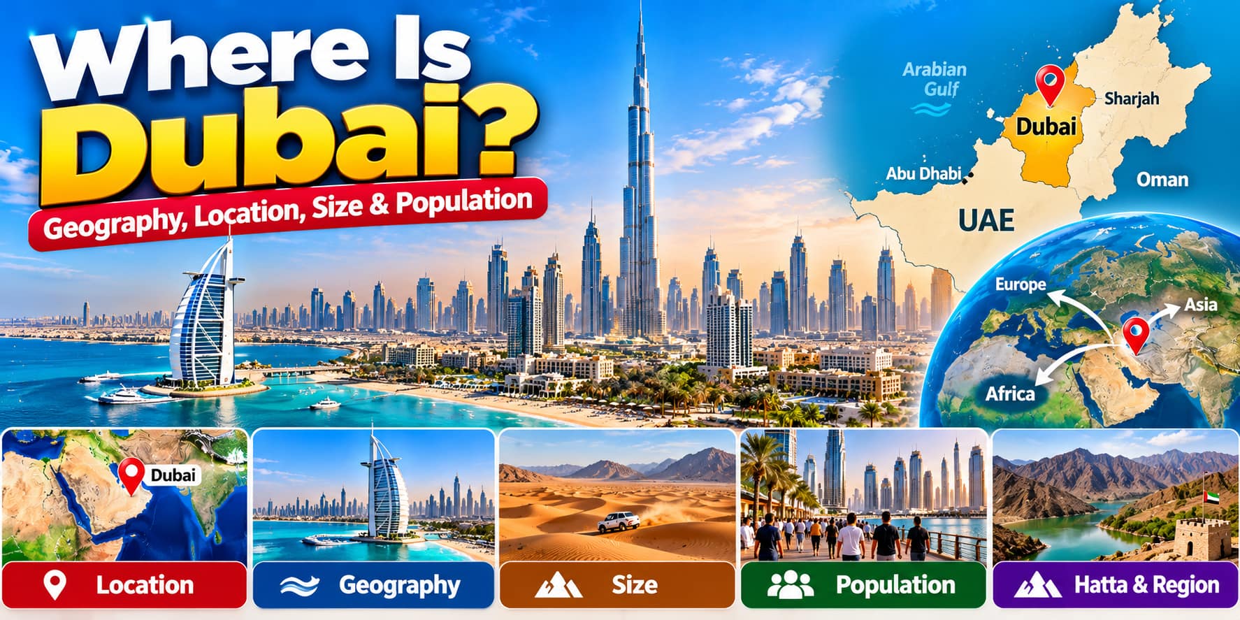








Where Is Dubai? Geography, Location, Size & Population
[…] Dubai Geography: Coastline, Desert, Islands, Creek & Hatta […]